We specialize in hard to find items

 (1)
(1)


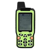
Magellan eXplorist 110 Handheld GPS
Share Tweet
*Price and Stocks may change without prior notice
*Packaging of actual item may differ from photo shown
- Electrical items MAY be 110 volts.
- 7 Day Return Policy
- All products are genuine and original


Magellan eXplorist 110 Handheld GPS Features
-
The eXplorist 110 GPS receiver provides core outdoor navigation with a sunlight readable color display and waterproof design
-
A vibrant 2.2" color transflective screen provides the best readability in direct sunlight
-
The World Edition includes a detailed road network, water features, urban and rural land use.
-
Download and view more than 20 unique characteristics of each cache and view, search, filter on the device. Details include name, location, description, hider, size, difficulty, terrain, hint, and recent logs created by other geocachers
About Magellan EXplorist 110 Handheld GPS
From the Manufacturer Magellan eXplorist 110 : Fundamentals for Outdoor Navigation Out of the box and ready to go, the Magellan eXplorist 110 GPS receiver comes with everything you need to explore the outdoors. A vibrant, transflective color screen allows for the best readability in direct sunlight. To zero in on the exact location of a geocache, favorite fishing spot, or the next summit, the SiRFstarIII GPS chipset provides accuracy of 10-15 feet (3-5 meters). To keep your outdoor adventure going all day long, the device is powered by two AA batteries for 18 hours of constant usage. The eXplorist 110 is rugged, waterproof, and submersible (IPX-7). All of this is packed into a small and attractive handheld form factor that can be hung around your neck with the optional Magellan lanyard or attached to your pack with the built-in carabineer hook. The eXplorist 110 is pre-loaded with the World Edition map, which includes a complete road network in the United States, Canada, Western Europe, and Australia and major roads throughout the rest of the world. This unique preloaded map also includes water features, urban and rural land use, and city centers. Regional versions of Magellan's Summit Series topographic maps are available for download to expand mapping coverage and level of detail. Overlay a series of different transparent compass styles on top of a pre-loaded worldwide map that show roads, water features, parks, and city centers. Access the dashboard screen that shows a mini-compass for quick reference and customizable navigation data fields, such as latitude, longitude, heading, bearing, distance to end, trip odometer, and many more. Go back to the map screen and view your active track, which is a series of digital breadcrumbs to record all yours movements. Mark your starting point (car, trailhead, parking lot…) with a waypoint and easily navigate back to that location at the end of the day. The eXplorist 110 supports paperless geocaching, which allows you to download more than 20 unique characteristics of each cache, including name, location, description, hider, size, difficulty, terrain, hint, spoilers, attributes, and last 20 user logs among a number of other details. Reference your track summary to keep track of your distance traveled, elevation gained or lost, complete travel time, moving time and stopped time, and average time to find. Easily reset your track summary statistics to track the details of your next geocaching adventure. No matter where you enjoy the outdoors, the eXplorist 110 GPS receiver will provide precise GPS signals thanks to the Satellite Based Augmentation Systems (SBAS) of WAAS, EGNOS, and MSAS; display coordinates in a myriad of different global systems, including UTM and WGS84; and accurately guide you to and from your next adventure, where ever in the world that may be. The eXplorist 110 GPS receiver provides core outdoor navigation with a sunlight readable color display and waterproof design. Highlight Features Brilliant, Sunlight Readable Color Screen A vibrant 2.2" color transflective screen provides the best readability in direct sunlight. World Edition Pre-loaded Map The World Edition includes a detailed road network, water features, urban and rural land use. Paperless Geocaching Download and view more than 20 unique characteristics of each cache and view, search, filter on the device. Details include name, location, description, hider, size, difficulty, terrain, hint, and recent logs created by other geocachers 18 Hours of Battery Life Go strong for an entire day (or more). No stopping to replace the batteries. Conserve battery life by putting the device into an advanced power saving mode. Suspend mode will turn off everything expect for GPS tracking. Wake up the device with a single click. Rugged and Waterproof The eXplorist 110 GPS receiver is submersible and tested to IPX-7 standards, which means it can withstand depths up to 1-meter for a total of 30 minutes. High Sensitivity GPS Th