We specialize in hard to find items

All Categories


*Price and Stocks may change without prior notice
*Packaging of actual item may differ from photo shown
- Electrical items MAY be 110 volts.
- 7 Day Return Policy
- All products are genuine and original
- Cash On Delivery/Cash Upon Pickup Available


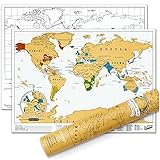
Collins: Philippines Wall Map - 24" x 35.25" - Paper Features
-
STYLISH CARTOGRAPHY: These beautiful natural colors help to highlight the physical features, making this perfect a perfect look for the classroom, home or boardroom.
-
MAJOR FEATURES: Map details include detailed road and highway networks, international borders, water depth, distance above/below sea level, and more!
-
TRUSTED PUBLISHER: This map is taken from the industry leading Comprehensive Atlas of the World series by Collins. The earliest versions of the atlas have been published since 1895, and today they are regarded as the world’s most prestigious and authoritative atlases and maps.
-
MAP SCALE: 1:2,500,000
About Collins: Philippines Wall Map - 24" X 35.25" - Paper
This map of the Philippines is a benchmark of cartographic excellence, taken from the industry leading Comprehensive Atlas of the World series by Collins. Published in full colour, this map of the Philippines is beautifully re-designed and fully updated. Islands including Luzon, Mindanao, Seram, and Samar are clearly identifiable, as are all major cities: Quezon City, Davao City, Antipolo and the Capital, Manilla. Accompanying the detailed map of the Philippines’ many islands is an inset map of the independent archipelago of Palau. Each element is carefully chosen to make the map a coherent and attractive visual guide to the Philippines. 24 x 35.25 inches. Printed on high quality thick paper strong enough for display on your wall. Your map is rolled and packaged in a sturdy tube to protect it during shipment.